
Find a Perris Street by Address
The first pass in a Perris street directory search should produce a place key, not a guessed name. Enter the address in the Riverside County ACR property search or the city zoning map. Save the APN, situs, legal description, tract or map reference, and the jurisdiction shown by the map. Then chain the place key into the recorder, permits, and historical sources.
That sequence keeps a street search tied to the same parcel even when a mailing name, street suffix, or house number changes. It also shows where the evidence becomes weaker. A deed names a grantor and grantee. A permit names project parties. A reverse directory may list an occupant at a date. None of those alone is a full household roster.
- Enter the address. Try the full street line, then a simpler suffix or unit form if the assessor search returns no match.
- Save the parcel key. Record the nine-digit APN, situs, legal description, tract, and map book or page shown in the result.
- Browse the block. Open Map My County or the Perris zoning map, click the anchor parcel, and note adjacent APNs and jurisdiction layers.
- Follow the transfer. Use the newest transfer document number to search the recorder, then read the grantor and grantee roles.
- Add time-based clues. Compare permits, census schedules, newspapers, or a reverse directory when the question is about people who occupied the address.
Perris Assessor Records by Street
The public ACR property screen is address and APN rich. It can display the property address, assessment number, GeoCode, property type, tag, acreage, legal description, lot and tract, map book and page, values, improvements, tax links, value history, similar sales, and transfer history. The sample result for 1395 Giosetta Street shows why the APN and transfer document number matter. The county suppresses owner names from the public web display under its policy, so a street directory cannot be built by typing an owner surname into the assessor screen.
Use one search key at a time and preserve the exact result. A situs address locates taxable land. A mailing address is where assessment correspondence goes and may point to an entity, agent, PO box, or person elsewhere. Neither field proves who occupies the building. The transfer tab is a bridge to the recorder, not a statement about a move-in date.
| Field label | Type | Required | Format or search note |
|---|---|---|---|
| Property Address | Text | One key | Street number and street name; simplify suffix if needed |
| Assessment Number | Text | One key | Nine-digit PIN or APN, often without hyphens |
| Search | Button | Yes | Opens the matching valuation result |
| View Tax Info | Result link | No | Moves to the tax-account context |
| Transfer History | Result section | No | Date, document number, and sale price when shown |
The recorder search capture is linked from the Riverside ACR recorder name search. It gives a visual reference for the address-first route.
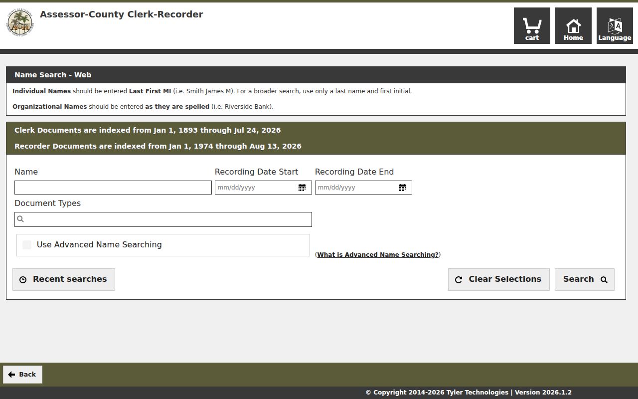
After the parcel is fixed, the street directory becomes a record-chain task. Save the result date because property data changes and a later reader may see a different transfer row.
Map Perris Parcels Along a Street
Riverside Map My County supplies parcel geography and layers for a street-by-street inspection. Search by address or APN, zoom until outlines and labels are legible, identify the anchor parcel, and click the adjoining polygons. The county viewer can expose parcel, city-limit, road, ZIP, community, district, flood, service-area, recorded-map, and assessor book or page layers. Availability can change, so record the layer name and date used.
The Perris zoning map adds a city planning view. Its search accepts a street address or the prefix `APN:` followed by nine digits. Layer toggles can show zoning and specific-plan context, including DTSP and PVCC resources. A plan boundary is a planning key, not a list of residents. The county and city layers also help separate an incorporated parcel from an unincorporated parcel that carries a Perris mailing name.
| Address | Geocodes a street location for parcel selection. |
|---|---|
| Assessor book and page | Lets a user browse the cadastral map reference. |
| Cities and communities | Filters geographic context without creating a name list. |
| Cross streets | Finds a segment when a full address is not known. |
| Select parcels | Clicks one or more polygons for a block view. |
| Buffer and measure | Shows spatial context around a point or boundary. |
GIS is a map aid, not a survey or title report. A parcel behind or beside the anchor may be adjacent without sharing the same mailing street. Use the map to gather APNs, then return to each custodian for the record itself.
Perris Street Address to APN
A parcel is a defined piece of land in a government assessment system. The APN is the county’s parcel identifier. A situs address is the physical location label. A plat or tract map shows how lots were divided. Keeping those terms separate makes a Perris address search much less prone to drift.
- Parcel
- A mapped land unit with its own assessment and legal description.
- Situs address
- The location address assigned to the land or improvement.
- APN or PIN
- The nine-digit assessment key used in ACR and GIS tools.
- Plat or tract map
- A recorded map that shows lots, blocks, streets, and map references.
- Criss-cross directory
- A reverse directory arranged by street and house number, sometimes with an occupant or business.
Modern Perris subdivisions often work best through tract, lot, map book and page, and APN. Older valley material may use rural routes, township and range, or a legal land description. Start with the contemporary parcel, then carry its legal description backward through the deed chain. Do not assume the modern street name was used in an earlier record.
Perris Records Searchable by Street
A street directory is a blend of address-keyed sources with different custodians and different proof value. The assessor and GIS can be searched by address or APN. The recorder is indexed by parties and document data, so it is not a direct street browse. City permits may be keyed to an address or project number. A qualified voter-file request can contain a residence address, but My Voter Status cannot browse a block. A reverse directory can show a listed occupant or institution for a particular edition.
| Record set | Keeper | Street view | Access |
|---|---|---|---|
| Assessor parcel | Riverside ACR | Situs, APN, legal and transfer facts | Free web search |
| County GIS | Riverside County | Parcel adjacency, jurisdiction and layers | Free interactive map |
| Recorder instruments | ACR Recorder | Owners and transaction parties | Free index; paid copies |
| Tax account | Riverside Treasurer-Tax Collector | Assessment number, bill, payment status | Free account view |
| City planning and permits | Perris Development Services | Projects, applicants, contractors, dates | Portal or city request |
| Voter information | California and Riverside election offices | Approved address fields only | Self lookup or qualified request |
| Reverse directories | Library or historical repository | Street order and listed occupant | Edition and holding vary |
Use the APN as the shared key where one exists. That link can join the assessor, GIS, transfer history, permits, and recorded deed. The street name then helps you choose historical directory pages and nearby addresses. An address chain is strongest when each row says what it can show and what it cannot.
Follow Perris Transfers Into the Recorder
The recorder’s official records index covers January 1, 1974 forward online, while older research is handled through Gateway books and indexes. Search options include name, document number, document type, map type with book and page, and advanced name searching. A document result can list party names and roles, recording date, document type, document number, and map or book reference. The index is not the deed image.
Use the transfer number exposed by the assessor before searching by a common name. If the number is known, order the regular or certified copy through the ACR channel. If it is not known, give the recorder the complete party names, instrument type, estimated date, and APN. For a pre-1976 mail request without a number, the staff search is limited to two years after the estimated year, so a narrow estimate matters.
Grantor means the party transferring or conveying an interest. Grantee means the party receiving it. The deed’s legal description is the check that the right parcel was followed. A recording date is not the date an occupant moved. The deed chain supplies ownership history, while a street directory must bring in a separate source for household history.
Perris Permits as Address Evidence
Perris Development Services can add a project layer to a street directory. Planning materials, environmental reviews, specific plans, building records, and code files may name an applicant, owner, contractor, APN, project number, date, or neighboring parcel. The city planning page is the best first route for address and property resources, while NextRequest can carry a defined request for a record that is not posted.
Code Enforcement accepts an exact subject-property address through its form, phone, letter, or in-person path. Its published workflow checks existing enforcement, violation history, and ownership before an inspection that normally begins within 30 days. No public case-name index was located. The City handles incorporated parcels; Riverside County handles unincorporated parcels even when the mailing city is Perris. The city’s four-or-fewer-digit versus five-digit address heuristic is only a clue, so confirm jurisdiction in GIS.
Permits and code files describe work or administration, not every person at the site. Use project and APN fields to confirm that a document belongs to the street segment, then avoid turning an applicant or contractor into an assumed resident.
Read an Old Perris Street
Historical street work needs more than a modern address. The verified Perris reverse-directory sample reports editions from Haines Criss-Cross in 1971, 1976, 1980, and 1985, and EDR, Cole Information, and Dun & Bradstreet snapshots in 1992, 1995, 2000, 2005, 2010, 2014, and 2017. In the consulted 1971 edition, E. Rider and Evans were not listed. Absence from a reverse edition is weak evidence, especially at the city edge or in a newer district.
Search alternate street forms, nearby numbers, adjoining streets, and the publisher’s title page. A reverse entry may show a street heading, year, ascending number, surname-first occupant or institution, and source page. The inspected 2017 pages show entries such as an elementary school and surname-first names. They do not show a universal spouse, occupation, owner flag, or phone field. The result is an edition snapshot, not a complete directory.
The older historical shelf and how to read these collections belongs on the Perris directory book page. For a current one-person question, use the resident lookup route rather than rebuilding a street chain around a name.
Perris ZIP and City Boundaries
USPS city names describe delivery geography, not incorporation. Perris mailing addresses can sit in unincorporated Riverside County, while an incorporated parcel can sit within a postal area that does not match a neighborhood or city edge. Check the USPS ZIP, the incorporated Perris boundary, and the assessor parcel jurisdiction as three separate facts.
Numbered downtown streets, lettered streets such as D Street, named arterials, rural roads, and newer curving subdivision streets can produce different search results across time. Annexation may change jurisdiction without changing the postal city or ZIP. No comprehensive official Perris street-renaming chronology was verified, so an older name should be proven by an ordinance, map, directory cross-reference, or recorded document.
A map layer can show a community, specific plan, district, or ZIP approximation. None of those layers creates a resident list. When a street directory question crosses a boundary, put the layer date beside the APN and ask the correct city or county custodian for the record.
What a Perris Street Directory Cannot Show
Even a careful street directory will miss people who are not named in a public filing, household members who are not parties to a deed, protected voters, utility customers, delivery records, and people whose historical address never used a modern street number. DMV address data is restricted under the Driver’s Privacy Protection Act and California law. Safe at Home participants receive special address protection. A map can show adjacent land without showing a household.
Lawful use. Perris address records are for personal, lawful research and record verification. Do not use an address, voter clue, court result, or directory entry to stalk, harass, threaten, or intimidate anyone.
Commercial people-finder tools may merge marketing and public feeds, but a match can be stale or assigned to the wrong person. Treat such a result as an unverified lead and return to the county, city, library, court, or state custodian for proof.
Protect Perris Block Data
A street directory should stop at the smallest useful record. Save APNs, map references, document numbers, dates, and source links. Do not publish a block roster made by joining unrelated sources. California voter-file recipients certify a permitted purpose and security duties, and the self-service status page cannot be used to browse neighbors. Utility data, protected school records, and confidential addresses stay with their custodians.
If a result is wrong, correct it at the source. The assessor, recorder, city, court, library, and election office each control a different record. A short correction request with the record number and the claimed error is more useful than a broad demand to erase every reference to a name.
A well-sourced Perris street directory is a map of evidence. It can explain the parcel and the record path without claiming more about a person than the source actually says.